By Pennell Paugh and Ran Meng
 The Republic of Mozambique is in southeastern Africa, bordered by the Indian Ocean to the east, Tanzania to the north, Malawi and Zambia to the northwest, Zimbabwe to the west and Swaziland and South Africa to the southwest. Maputo, which is the capital city, is the largest city in the country.
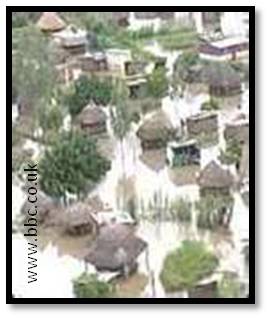
Mozambique is one of the most poverty stricken and underdeveloped countries of the world according to several peer-reviewed publications. Recurring natural disasters – droughts and floods – have taken their toll on the country.
“People are malnourished – they already do not have food, but when you have no water it becomes very difficult. The people in our district have been living on wild berries and fruit, but in some places we do not even have enough of that,” said a gaunt Fernando Muchanga, a local government official in the Buzi area of Sofala province in central Mozambique.
Zambia, which is located in the south of central Africa, is home to the Victoria Falls – one of the Seven Natural Wonders of the World. The country experiences a dry winter May to September; a hot and dry season October and November; and an even hotter rainy season December to April. The temperature has increased for the country over the past 40 years, at 0.29 degrees centigrade per decade. Current predictions state that rainfall will decrease in the winter which will exacerbate drought conditions throughout the country.
Most Zambians depend on agriculture. Like Mozambique, severe drought is one of the more serious conditions to threaten the country. Additionally, floods, extreme heat, and a shorter rainy season all contribute to a decrease in the quality and quantity of water available for safe consumption or for the maintenance of crop yields. These extreme weather events affect energy, infrastructure and increase the risk of cholera, malaria and other diseases to strike a population.
The government has redirected funds from other programs to improve their disaster response system. However, help from other countries is needed to cope with the effects of climate change; a National Adaptation Plan of Action (NAPA) was launched in early 2010 and is responsible for developing a national climate change response strategy.
The African Upper Air Data Rescue Project is concerned with conserving the pilot balloon (pibal) and radiosonde data that has been collected over the years. IEDRO’s data rescue efforts in Zambia and Mozambique have been considerable. We hope to help NAPA and the government of Mozambique to improve predictions for their disaster response systems.
References
Heath, Tom. “Zambia Climate Change Briefing.” 2010. Web. 4 Nov. 2011 www.wsup.com
Schleupner, Christine. “GIS as integrating tool in Sustainability and Global Change.” Reports on Earth System Science (2009): n. pag. Max Planck Institute for Meteorology. Web. 3 Nov. 2011. www.mpimet.mpg.de
“Climate Change: the Zambian Story.” United Nations Development Programme (UNDP). 5 Jan. 2010. Web. 4 Nov. 2011. www.undp.org
“Martinique.” Wikipedia: The Free Encyclopedia. Wikimedia Foundation, Inc. 22 July 2004. Web. 3 Nov. 2011, wikipedia.org
UNEP (United Nation Environment Programme). “Climate Change in the Caribbean and the Challenge of Adaptation.” Regional Office for Latin America and the Caribbean. Oct. 2008. Web. 3 Nov. 2011. www.pnuma.org
Wikipedia, Zambia, en.wikipedia.org/wiki/Zambia
Wikipedia, Mozambique, en.wikipedia.org/wiki/Mozambique
Preventionweb, Zambia – Disaster Statistics, www.preventionweb.net
IRIN News, October 24, 2011, “Mozambique: Drought after drought”. www.irinnews.org
Comments are closed.