By Luisa Cristini, PhD, University of Hawaii at Manoa.
[Note from the editor: This is the third in a series of blog entries that will focus on introductory topics in climate dynamics and modeling, and will be a great insight into the current understanding of the science.]
The cryosphere is the portion of the Earth’s surface where water is in solid form. It includes snow cover, freshwater ice (lake and river ice), sea ice, frozen ground (or permafrost), glaciers, ice caps and ice sheets.
Snow and Freshwater Ice
The snow cover has the largest extent among all the components of the cryosphere. The majority of the snow cover is located in the Northern Hemisphere, because land surfaces at high latitudes are much more extensive than in the Southern Hemisphere. The same is true for the freshwater ice that forms on rivers and lakes in winter. Snow cover and freshwater ice have a very strong seasonal cycle and often nearly disappear in summer.
Sea Ice
Sea ice forms when seawater freezes. Its concentration is defined as the fraction of a surface of interest (pixel from a satellite image, area surrounding a boat, etc) that is covered by sea ice and ranges from 0 (corresponding to open ocean) to 1 (corresponding to a continuous ice pack). Sea ice covers a similar area in both hemispheres, but its seasonal cycle is larger in the Southern Ocean where the majority of the ice cover is first-year sea ice (i.e. sea ice that has not survived one summer). Because of the large thermal inertia of the ocean, the minimum and maximum sea ice extent shift every couple of months compared to the snow cover on land.
Permafrost
The seasonally frozen ground covers a large fraction of the continents in the Northern Hemisphere. Where the annual mean temperature is below -1°C (approx. 30°F), the ground can be perennially frozen below a top layer that melts in the summer. Permafrost is estimated to cover more than 20% of the land area in the Northern Hemisphere and its thickness can exceed 600 m (1,969 feet) at high latitudes. Further south this layer thins, and the permafrost becomes discontinuous.

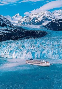
A Glacier in Alaska flows out of the mountains and calves into the Pacific Ocean.
Ice Sheets and Glaciers
The majority of ice (and freshwater) present on Earth today is located in the two big ice sheets: the Greenland and Antarctic ice sheets. The Antarctic Ice Sheet (AIS) is itself divided into two parts, East and West Antarctica, roughly corresponding to the eastern and western hemispheres relative to the Greenwich Meridian. Ice sheets are formed by the accumulation of snow layers over tens of thousands of years. As new snow falls on the surface of the ice sheet, the pressure on the non-melting older snow layers increases, transforming them into ice. Ice sheets and glaciers are not stationary but flow slowly toward their margins, and the highest velocity (several kilometers per year) is reached in ice streams. Due to the weight of the ice sheet, the bedrock underneath is depressed and, in some areas, it is below the sea level as is the case in most of the West Antarctic ice sheet.

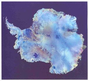
Image of Antarctica taken from a polar-orbiting satellite. Much of the perceived land area is actually ice shelves extending into the ocean. The prime meridian runs to the top of the image.
Ice Shelves and Icebergs
Antarctica is surrounded by ice shelves, floating platforms made of ice that originated from the continent and flowed down the coastline into the ocean. Antarctica’s largest ice shelf is the Ross-Filchner shelf, which covers more than 800,000 km2 (almost 309,000 square miles). Ice shelves and glaciers that reach the shore can calve icebergs into the sea. These can drift over long distances, pushed by ocean currents and winds. Icebergs are thus found in the open ocean, but they should not be confused with sea ice. Icebergs consist of freshwater and are usually much thicker (sometimes more than 100 m), while sea ice is salty, thinner (a couple of meters) and is formed directly from freezing sea water.
Snow and ice have a very large albedo, i.e. they reflect solar radiation and therefore play a major role in the global heat balance of the Earth. By storing and releasing latent heat, they affect the seasonal cycle of the surface temperature. They are also good insulators and reduce the heat loss from the underlying surface (land or ocean) toward the cold atmosphere in winter. When sea ice forms, only a fraction of the salt present in the water is trapped in the ice, the remainder being ejected towards the ocean, a process called brine rejection. Because of this, sea ice formation increases the salinity at the ocean surface while melting sea ice is associated with surface freshening. Sea ice drift is associated with horizontal freshwater transport.
Ice sheets store large amounts of water on land and any change in their volume has a considerable effect on sea level. It is estimated that if all of the ice sheets melted completely, the sea level would rise by more than 60 m (197 ft). On the other hand, the melting of sea ice and ice shelves does not influence sea level because floating ice displaces its own weight of sea water and the melted water thus simply replaces the volume of ice previously below sea level. The presence of cold air on the ice sheet also has a regional influence, cooling the surrounding areas.
Reference
Goosse H., P.Y. Barriat, W. Lefebvre, M.F. Loutre and V. Zunz, (2012). Introduction to climate dynamics and climate modeling. Online textbook available at http://www.climate.be/textbook.

Comments are closed.